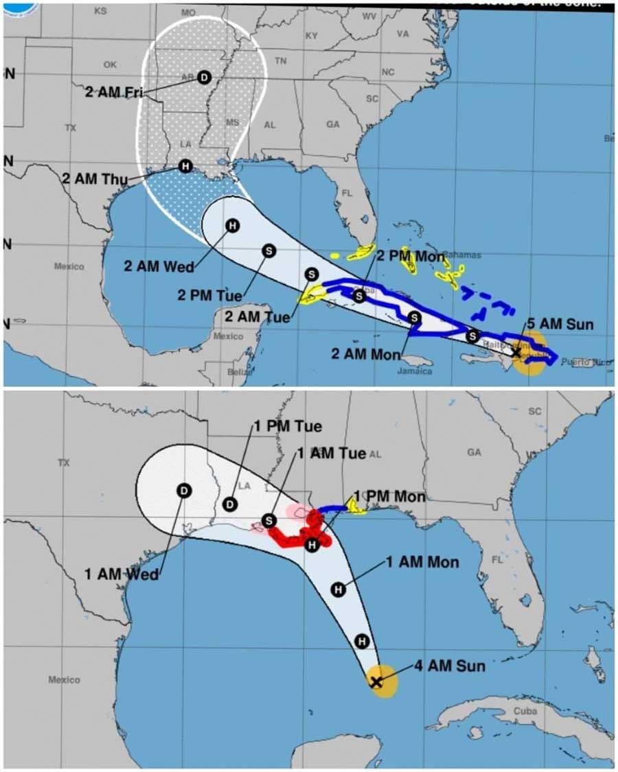
Beginning on August 20th, your Inframark management team began preparations and tracking of what was known then as tropical disturbance number 13. TD 13 intensified and became tropical storm Marco. As of this Sunday morning Marco is forecast to begin a counterclockwise movement and make landfall as a hurricane on the Louisiana coast. At that point, the storm will continue on a west-northwest track taking it through Louisiana and eventually coming in to East Texas just north of Beaumont. At this point it will be a tropical depression.
Additionally, we are watching tropical storm Laura. This system is currently bringing inclement weather to the Dominican Republic, Haiti and the southeastern Bahamas. Experts predict the storm will continue on a north northwest track, strengthening as it moves through the Gulf of Mexico.
The storm is still too far out to forecast a point of landfall, but experts generally agree it could be anywhere from Houston all the way to Mississippi. Additionally, there is much discussion on the impact Laura may or may not exert on Marco as these two storms potentially are going to be close.
With the amount of data that we have been presented and the significant discrepancy in its interpretation by the weather experts, INFRAMARK has decided to prepare all of our clients as if both storms are going to make a direct hit on the Houston area.
Here are the steps we have taken:
- We are in direct contact with Jeff Lindner from Harris County OEM to assist us in understanding the forecast.
- We have 2 daily briefings to review the data points with our emergency team.
- All facilities have been placed in a hurricane prep condition ready to withstand the unique weather characteristics that are brought about by hurricanes.
- We have verified fuel delivery with our multiple fuel vendors.
- We have placed our Shelter in Place Packs (SIPPS) in strategic locations for our employee’s safety.
- Our customer service and billing teams are set up to perform their functions remotely via the internet.
- Our 2-way radio system is active and ready in the event cellular communications are compromised.
- We will be deploying the mobile command center (MCC) Monday AM.
The MCC is a self-contained mobile vehicle that has 100 gallons of diesel, an 85kW generator, communications tools and food to keep our 24-hour emergency team ready.
As always, we hope that this becomes a non-event and dissipates quickly. If you have any questions about anything related to the storm or your district preparation, please reach out to your designated account manager for more information. If anything changes, we will share it with another special edition of our customer first newsletter.
NHC forecasting as a Sunday morning: